BY
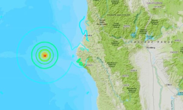
A 5.8 magnitude earthquake struck off the coast of Northern California on the evening of March 8, the U.S. Geological Survey (USGS) said.
At least 2,600 people said they felt the earthquake that struck 86 kilometers (53 miles) west of Petrolia, California, at at 6:59 p.m. Sunday, according to the USGS website. The earthquake had a depth of 2.2 kilometers (1.37 miles).
The agency initially reported the earthquake as having a magnitude of 5.9, but it was later downgraded.
The quake could be felt in nearby coastal cities, according to reports. San Francisco, Marin County, and parts of the East Bay reported light to moderate shaking, according to ABC 7.
In the hours following the preliminary quake, the USGS recorded a total of five aftershocks near the epicenter, with magnitudes of 2.5, 2.9, 2.5, 4.9, and 2.5 respectively, the most recent of which had a depth of 0.3 kilometers (o.18 miles), and struck 59 kilometers (37 miles) west-northwest of Petrolia.
The USGS forecast a chance of smaller aftershocks could continue to occur over the next week near the epicenter, and has advised people to be wary when in or around vulnerable structures, such as unreinforced masonry buildings. There are likely to be up to six magnitude 3 or higher aftershocks, the USGS said.
There are no reports of damage so far and the National Tsunami Warning Center has not said a tsunami is expected.
California is typically struck by two or three earthquakes with a magnitude of 5.5 and higher every year, according to the National Earthquake Information Center (NEIC).
Last July, California was hit by a 7.1 magnitude earthquake—the region’s most powerful quake in nearly two decades.
California in October rolled out the nation’s first statewide earthquake warning system, designed to detect seismic waves and alert residents through a mobile phone app even before the ground starts shaking.
Feds Order California Reservoir to Be Drained
Last month, the Federal Energy Regulatory Commission (FERC) said a Silicon Valley reservoir must be drained because its dam could break during a major earthquake and flood numerous towns and cities in the San Francisco Bay area.
The FERC said the lake has to be drained by Oct. 1, saying the risk posed by the dam on the Anderson River in Santa Clara County is too great.
“It is unacceptable to maintain the reservoir at an elevation higher than necessary when it can be reduced, thereby decreasing the risk to public safety and the large population downstream of Anderson Dam,” wrote David Capka, the head of FERC’s Division of Dam Safety and Inspections, in a letter to the agency that manages the dam, the Santa Clara Valley Water District.
The dam, which was built in 1950, is located between San Jose and Morgan Hill, and it can hold 89,073 acre-feet of water. According to the San Francisco Chronicle, it holds more than half what the district has stored.
Capka said the reservoir must be drained “as quickly as you can” and the dam must be fixed before the winter of 2021 and 2022.
Local officials agreed that the dam needs to be retrofitted but she said that draining the reservoir could result in unintended consequences.
“Valley Water agrees with the Federal Energy Regulatory Commission that it is vital we reduce the dam safety risk and move as quickly as possible with the Anderson Dam Seismic Retrofit Project,” Valley Water CEO Norma Camacho said in a statement. However, Camacho added, “The demand to empty Anderson Reservoir could result in unsafe consequences.”
Camacho said draining the reservoir might cause fish die-offs and significantly impact sensitive native fish, amphibians, reptiles, wetlands, and other habitats. Water supplies would be strained, and the district would have to find another source outside the county especially if there’s another drought, she added.
Jack Phillips and Reuters contributed to this report.


Republished with Permission The Epoch Times SUBSCRIBE
Get Citizensjournal.us Headlines free SUBSCRIPTION. Keep us publishing – DONATE


