Ventura County Public Works Agency’s (VCPWA) Watershed Protection District (WPD) is working to reduce repeated flooding in the Casitas Spring community and State Route (SR) 33 with the Fresno Canyon Diversion Project.
The new Fresno Canyon Diversion, which will take nine months to complete, constructs a new storm drain facility, approximately 1,500 feet in length. The project includes installing a 9-foot in diameter, reinforced concrete pipe (RCP) from Fresno Canyon to the Ventura River for conveying stormwater, debris and sediment.
Project construction began in April 2019, and due to the project’s connection to the Ventura River and proximity to the Ojai Valley Bike Trail, the pathway will be closed between the Arroyo Mobile Home Park and Foster Park for five months beginning August 15, 2019. For the Ojai Valley Bike Trial closure period, there will be an alternate bike route for trail goers from Santa Ana Boulevard, Santa Ana Road and Casitas Vista Road.
“The implementation of this project will assist in improving the safety of our communities that are highly susceptible to storm damage,” said Glenn Shephard, director of VCPWA Watershed Protection District. “Our goal is to help reduce the amount of flooding and debris flow these communities face during rainstorms.”


![]()
![]()


Has the bike path reopened in time for Martin Luther King weekend?
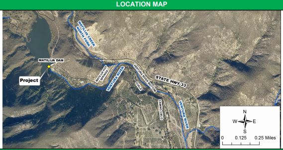
The map is entirely incorrect. The project is not located anywhere near the Matilija Dam, which is north of Ojai. The project is south of Ojai, near Casitas Springs.
The map for this project is on page 5 of this document from Ventura County Department of Public Works:
http://pwaportal.ventura.org/CSD/ConstructionProjects/Final%20VCWPD_CIP_2017.pdf
The location map is incorrect. It shows the project at Matilija Dam, not Fresno Canyon through Casitas Springs.
It’s marked in yellow. The map is from Public Works